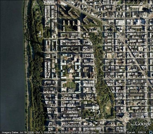
Morningside Heights' history is one of rural farmland surrounded by country estates, interrupted for a brief spectacular moment in the Revolutionary War with the Battle of Harlem Heights in 1776 (one of Washington's and the Continental Army's few victories). In 1821 the Bloomingdale Insane Asylum moved to the quiet plateau, followed in 1843 by the Leake and Watts Orphanage (both continue their work today in Westchester). For nearly 50 years the two institutions existed in close proximity on the windswept, sun-soaked plateau. But in quick procession starting in 1887, St. John the Divine would take over the orphanage site and Columbia University replaced the insane asylum, accompanied to the area by St. Luke's Hospital and Teachers College. Grant's Tomb would open to the public in 1897. Later, other institutions would follow, including Union Theological Seminary, Riverside Church, and Julliard (which eventually moved to Lincoln Center and was replaced with the Manhattan School of Music).
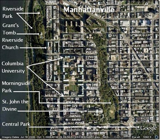
Here’s the same image with many of the landmarks identified. Broadway is just to the left of the “M” in “Manhattanville.”
The image below is down in the valley of Manhattanville, looking west along 125th Street toward the Hudson River. For an island whose nearly every hill was used to fill in every dale, the two viaducts that connect Morningside Heights with Hamilton Heights over the valley of Manhattanville are evidence of a terrain the city couldn't conquer. In the foreground is the viaduct that conveys the no. 1 subway along Broadway (the ground actually drops out from under it), and beyond it is the Riverside Drive viaduct. Both traverse the old Hollow Way. In the image above, the photographer would be standing just above the “M” in “Manhattanville.”
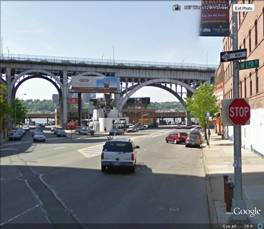
Here's the Riverside Drive viaduct (farther back in the above image). 125th Street goes through the wide arch while St. Clair Place goes through the narrower arch. See the street sign for 129th Street intersecting 125th Street!? That's part of the story which we'll see soon. This viaduct was built in 1900; the one for the subway was built shortly after.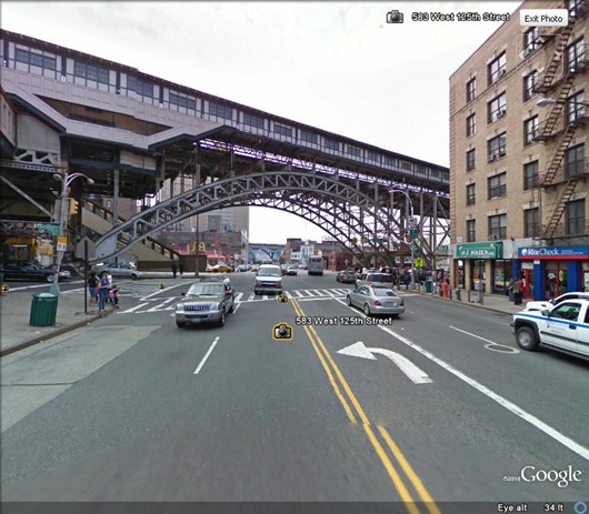
An old postcard view of the Riverside Drive viaduct from just north of Grant's Tomb. See the wider, slightly lower arch to the right of the lamp post?
Most of the west side of Manhattan is an ever-rising chain of plateaus followed by valleys, with an occasional drop all the way to sea-level before steeply rising again. And just as people today opt for elevators instead of stairs and cluster their cars in parking lots close to supermarket, people in the past didn’t waste energy getting from point A to point B. Before the grid was laid out scores of roads criss-crossed town linking travelers to ferry terminals and bridges (the few that there were), and to other locales within the city. With the coming of the subway (and perhaps even moreso cars) topographical considerations became a non-issue when traveling. Only skaters and bikers consider hills when planning a trip through Manhattan.
One side effect of this paradigm shift in mass movement has been an interesting case of historical geographic amnesia. Considering the wear on horses, or a foot-traveler's exertion, if there were viable alternatives, why would someone climb a hill just to go down again? We'll take a closer look at that in a moment.
Another mind eraser has been Central Park. In addition to the people displaced by the creation of the park in the mid-1800s (perhaps most famously from Seneca Village) many old roads were also obliterated. Let’s resurrect a few old roads, starting a bit farther downtown.
Union Square and Madison Square
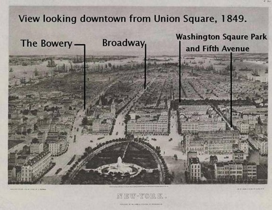
The image below is of both parks. Just below Union Square a number of roads converged, three of which can still be seen today (in fact it’s why it's called “Union” Square). From right to left the roads entering Union Square are: The Bowery (the oldest), Broadway (being paved up to this point by the late 1830s), and University Place (formerly Wooster Street, but named for NYU in 1838).
Broadway leaves the top left corner of Union Square and slices past the lower left corner of Madison Square at 23rd Street. As an interesting side note, there is no Broadway between 14th and 17th Streets!
Here’s an old view from the top of Union Square looking south. (I left out University Place, but Washington Square Park and Fifth Avenue are shown.)
If a traveler were heading north along any of these three uptown roads from Union Square, they were in an area called The Common Land. Going a few "blocks" farther, they could choose from a host of uptown roads to continue their journey. Together the two parks constituted a hub for foot, cart and carriage traffic, a half-mile long switching station.
Below is an 1828 view of Madison Square
Except for today's Broadway, none of the old roads leading out of the area of Madison Square exist today.
Important note: The Boston Post Road, and different parts of it, had a number of names through history, including: the Wecksequageck Road, the Kingsbridge Road, and the Eastern Post Road. Old roads were forever tapping into new roads, and new roads were always being built while old ones straightened out, leaving a historical path of nomenclative chaos and destruction up and down the island.
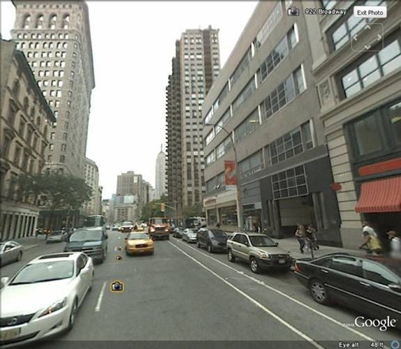
Just because it's interesting, here is the same view today looking up Broadway from 21st Street. It's hard to imagine the gambrel roofs, gable peaks, chimneys and porches of 1828! The tall, beautiful building to the left is an uncharacteristic view of the Flat Iron building. The Bloomingdale Road is Broadway today, and bears to the left of the small building in the middle of the street in the distance. The Boston Post Road no longer exists. Fifth Avenue bears to the right of the small building, past the trees of Madison Square
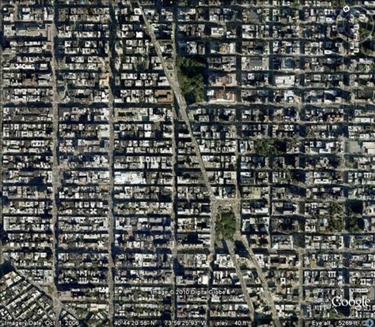
Now let’s look at the bigger picture and at some of the roads that started out from this area. Below is an image of Manhattan from 14th Street to around 125th, including Morningside Heights in the upper left--notice the green arc of Morningside Park near the top left corner of Central Park.
Here were the main roads that led uptown starting at around 23rd Street. They're color coordinated with the map below, along with the years they existed before the grid.
Broadway is often described as the main cosmopolitan thoroughfare and an old Native American path—the "road of roads." But that historic Broadway is downtown; throughout most of history the section of Broadway from 23rd Street to Morningside Heights was a country road named by the Dutch for its beauty and its “vale of blooms.” Though the Bloomingdale Road was considered a "main thoroughfare," the road most used to go in and out of town was the Boston Post Road through its many names and incarnations.
An excerpt from Valentine’s Manual of Old New York, 1923 of Laura Dayton Fessenden’s reminiscences gives an idea of the nature of this part of town, along with the people who traveled the Bloomingdale Road.
When I was a little girl, in 1867-1868, the upper part of Manhattan Island, on the west or Hudson River side and north of 59th Street, was suburban.
There was one line of street cars that penetrated ''through the quiet" at stated intervals (but never on schedule time) to the jingling of not unmusical harness bells. The route was up Eighth Avenue, and Eighth Avenue skirted the west side of Central Park, as it does to-day, and Central Park was in 1867 a comparatively new city acquisition.The coach line along Eighth Avenue that Fessenden mentions opened in 1851 and originally extended only to 59th, a relatively recent development in the scheme of things. Still, even with that additional transit line, it seems those who traveled the Bloomingdale Road did so because they lived in the area, they were visiting (or going themselves) to any of charitable institutions or houses of refuge in the area, or they were out for a ride in the country (which was a popular pastime). But it wasn't a completely cloistered part of town; there were inns, hotels and taverns up and down the west side. Yet, if one were on business, or simply entering or exiting the city, today’s Broadway on the west side was just about the last route you’d opt for.
There was also once in every two or three hours (I think it was from six in the morning until six at night) a stage line that followed the windings of the Bloomingdale Road (now Broadway) through Bloomingdale, Manhattanville, Carmansville and on to Washington
Heights.
It might be interesting to mention en passant that the people who used these street cars and stages were mostly known to one another, not perhaps personally, but as belonging to the same country-side neighborhood.
As an instance of this fact, I recall a tall, dark, sallow man, who always wore a cloak and who was a tea merchant. He was a brother of Susan B. Anthony and, as Miss Anthony was then considered to be a young woman of startlingly progressive ideas, we children gazed upon her brother with interest. Then along the Bloomingdale Road there lived a colony of actors, and Mr. Joseph Jefferson's little daughter, who afterward married the English novelist, Fairjohn, was almost like going to the theatre to ride beside in the car or the stage.
The stages only ran on week days, for an old observance of the Sabbath was still held in half remembrance in New York. Of course, there had been a great change since 1830, for in his book, "The Last Days of Knickerbocker Life in New York," my father says: "When the church bells had ceased tolling and services were about to commence, heavy iron chains were drawn tightly across the streets containing the 'Houses of Worship' and only the doctor's gig, on an errand of mercy, was allowed to pass through the barred roadway"; and again he says: "Sometimes on a lovely summer afternoon a brave sinner would get out his carriage and pair for a drive from town into the country, knowing that for this lapse, and an indefinite period thereafter, he would be a subject for intercession at family evening prayers."
To go back to the stage route in 1867, by the time 60th Street was reached the Bloomingdale Road and the contiguous neighborhood became country stretches of land, filled with lovely homes, many of them like Marshall Hall at 92nd Street, having been the country seats of representative New York families since pre-Revolutionary times.
And the names of the roads say a lot: The “Post” road was for destinations upstate and New England; it’s not a puzzler to figure why “Albany Avenue” was so named; and the Middle Road is self-described. But Bloomingdale, in addition to being a description of the whole of the bucolic west side, was a village at around West 100th Street. And though by Ms. Fessenden's time the Bloomingdale Road passed through Mornignside Heights to points beyond, it originally ended at the top of Morningside Heights and was, in effect, a west side cul-de-sac.
It’s also an indication of traffic that there were so many roads branching off the Boston Post Road so far downtown, going in the same basic direction. There appears not to have been the demand on the Bloomingdale Road that there was on the Boston Post Road, such as it was to necessitate at least two additional parallel roads to accommodate the traffic.
Even if you were going to the village of Manhattanville just above Morningside Heights (or delivering goods from the ferry terminals), it made sense to skirt around Morningside Heights. And those roads are actually still there!
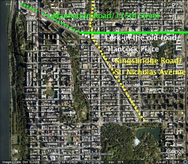
Today, three separate roads link together to make the old route that bypassed Morningside Heights leading to the ferry terminals and the village of Manhattanville. The route is formed by St. Nicholas Avenue (yellow)-Hancock Place (white)-125th Street (green). The old path went: Kingsbridge Road-the fork in the road-Manhattan Road.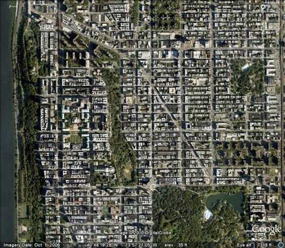
The solid green line in the image below is 125th Street, on the grid proper. So intransigent was the route that 125th conformed to it! That's why 129th Street intersects it.
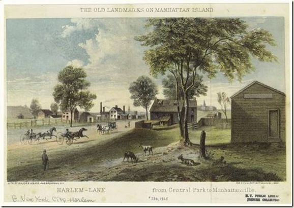
Below is and old postcard view from 1865 of the Kingsbridge Road somewhere along the yellow dotted line leading from Central Park on the way to Manhattanville. Though it’s labeled “Harlem-Lane from Central Park to Manhattanville” the road was more generally known as the Kingsbridge Road (and is today’s St. Nicholas Avenue).
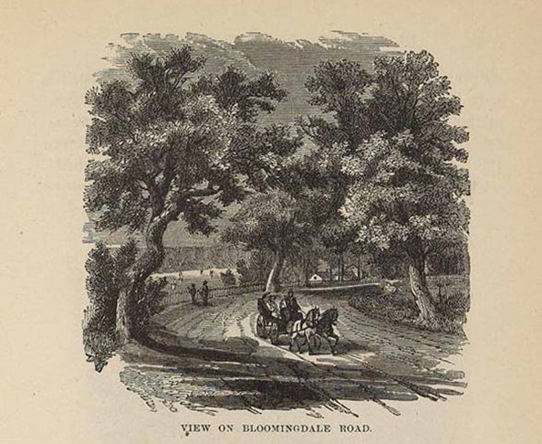
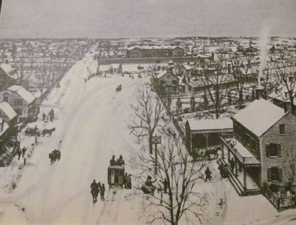
Back on the Bloomingdale Road, here’s a picture from before it became The Boulevard, and then ultimately Broadway. The Palisades appear to be in the background.
Some of the theories I’ve heard and read explaining the difference between the east and west sides of the city are that: 1. the west side developed later than the east side; 2. the Tweed scandal of the 1870s set development of the west side back a generation; 3. real estate investors and speculators put their money in the east side earlier. All of these make sense and are true, but even they don't explain why the two neighborhoods would have such different characters. And the reason all those things are true probably has to do with the fact that the east side of the city always had much more traffic. And not just more traffic, more cosmopolitan traffic--in a city that was the very definition of the term!
The Bloomingdale Road may have been a main thoroughfare, but it wasn’t a "through" street for many years, and when it was, there were many smarter, more energy efficient ways to travel through the city. Commerce absolutely would have preferred to flow up and down the east side rather than deal with the west's terrain. With commerce comes people, ideas, and "energy," everything that defines a city.
It doesn’t help matters either that the old suburban road carries the name Broadway today, making it easy to infer that it has some relationship with the Broadway made famous for its shops, theaters, hotels and the hustle and bustle of city life.
The suburban, more quiet disposition of the west side has existed throughout history, and in relative terms has carried down to today. That's why the west side is different.

