The Viele Map

"No other city is so spitefully incoherent"

--James Baldwin

Welcome to Manhattan Unlocked Walking Tours

Discover hidden-in-plain-sight history and have fun decoding the streetwalls of the city on our multi-faceted walking tours. Manhattan Unlocked answers the question every New Yorker and visitor has asked at some point: "why is this building next to that building?" We take that question to the nth degree and ultimately let the built environment--the city itself--tell its own story, and it's an incredible story to tell! In addition to the million-and-one things on the surface of the island (architecture, history, culture, commerce, immigration, etc.), we look at how ancient geographic features, and long gone and forgotten transit systems, had everything to do with how the city would grow and develop.

About Us

Manhattan Unlocked began as a blog over a decade ago as an effort to decode and make sense of the streetwalls of the city. What most people consider New York City is an architectural complex, and constellation of neighborhoods, stretching almost 5 miles from the Battery to Central Park. Yet, what looks like a jumble of buildings on almost any given blockfront, I realized long ago, couldn't be random. There had to be reasons, there had to be patterns. Neighborhoods too, whether made up of cast iron buildings or skyscrapers, had to be part of some greater, overarching narrative that described the city's development. There had to be some way that Tribeca and Museum Mile were part of the same story.

I soon realized taking on the search for the single-story--the "unified theory"--behind New York's instantly recognizable yet wholly enigmatic built environment, I needed to hit the pavement so to speak. Manhattan Unlocked walking tours began. I had to discontinue the blog long ago, but hope to start posting again soon. Join us on a walking tour, or wait for the book, Build: The History of of New York City on the Island of Manhattan.

Our Walking Tours

Join Us on a Walking Tour...Click the big blue button below for details, or to book any of the following tours (don't forget to read our TripAdvisor reviews!):

  • Midtown Manhattan Art and Architecture Walking Tour
  • Midtown west, Times Square, Rockefeller Center, Park Avenue

  • Holdouts! Based on the Book by Alpern & Durst
  • Midtown east, Grand Central, Rockefeller Center

  • Recreate the Most Requested Walking Tour of 1840s New York
  • Astor Place, NoHo, SoHo, Chinatown, Foley Square

  • A Disastrous History of Housing the Poor
  • (starts May 15, 2024)

    Foley Square, Chinatown and The Lower East Side

  • Explore the Ruins of a Forgotten City in the Middle of Manhattan
  • (starts May 29, 2024)

    Madison Square, Nomad, the Flatiron District, Chelsea

In the meantime, the old blog for "testing the waters" remains below.

Click Here to See Tours

Sunday, June 5, 2011

42nd Street to the Battery: 1855

The last post showed the city from 63rd Street to the Battery by putting together two pictures from the 1850s.  Here they are again; click here to read the original post.  A painted line runs down Fifth Avenue in both pictures, and you can see the dome and flag of the Crystal Palace on 42nd Street in both. The top one is from 1855, the bottom from 1858.


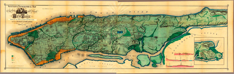
This post looks more closely at the first image.  Most people know that the city grew from the bottom up, but what stands out is how much the city also appears to have grown from the outside-in. Many of the blocks in the center of the island have only a handful of structures.


There are a few notable geographic features visible in the picture.  Murray Hill was a swath of land owned by a wealthy Quaker family during the Revolution.  It’s where Mrs. Murray famously (perhaps apocryphally) delayed general Howe with her hospitality, allowing General Washington and the Continental Army to escape to the north of the island. As good Quakers, though, the Murrays did not take sides in the Revolution (and their economic interests, which were mainly shipping, straddled both sides).  For their neutrality, many Quakers were expelled after the Revolution, and although they were permitted to return a short time later, many opted to remain in England.

You can detect the slope in the terrain of the actual hill extending from around 39th Street downtown past where the Empire State Building is today.


And you can see the Murray Hill railroad tunnel that today is an 8 block-long covered traffic tunnel running down the middle of Park Ave south of Grand Central.  Below, the future tunnel appears as narrow empty blocks between the two sides of Park Avenue (then, 4th Avenue) that straddled the sunken passage. Today Park Avenue has one of the widest medians of any of the avenues, the only indication above ground of the dozens of railroad tracks running below the avenue from Grand Central (to the left out of the scope of picture) up to 96th Street.  


The passage was cut through Murray Hill so the railroad wouldn’t have to climb up it.  After 1855 (the year of the picture), railcars were required to be horse drawn below 42nd Street so as not to be a nuisance to the growing population.  Here’s the tunnel today.  (I made these especially big and they overlap the side panels, but it's worth it to see the pictures).


It’s also interesting to see what an ordinary road Broadway was in this part of town.  Back in 1855 above 23rd Street it was the Bloomingdale Road, and would be renamed The Boulevard in 1866, finally taking the name Broadway in 1899.
 
And there’s a good reason Madison Square and Herald Square do not appear to be significant parts of town…


The center of town back in 1855 ran the stretch of Broadway from today’s NoHo and SoHo all the way to to City Hall.  The town center would begin its shift to Madison Square around 1859, with the construction of the Fifth Avenue Hotel.

Here’s a rather dramatic view from the same perspective, using Google Earth.  The NYPL and Bryant Park have replaced the reservoir and the Crystal Palace (though that structure only stood five years, 1853-1858).


The commercial center of the city moved up Broadway, which from the tip of the island to within a few blocks of Union Square is uncharacteristically straight. The Bowery (in yellow) was the high ground, and the main route in and out of lower Manhattan though most of history. The city grew first up the Bowery before Broadway bridged Canal Street and the center of the city shifted over to Broadway around the 1830s.